Digital Elevation Model API - Terrainizer
av SC DE VIS SOFTWARE SRL

Digital Elevation Model API - Terrainizer , a solution to digital terrain model
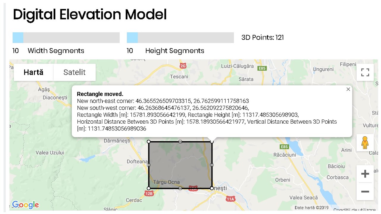
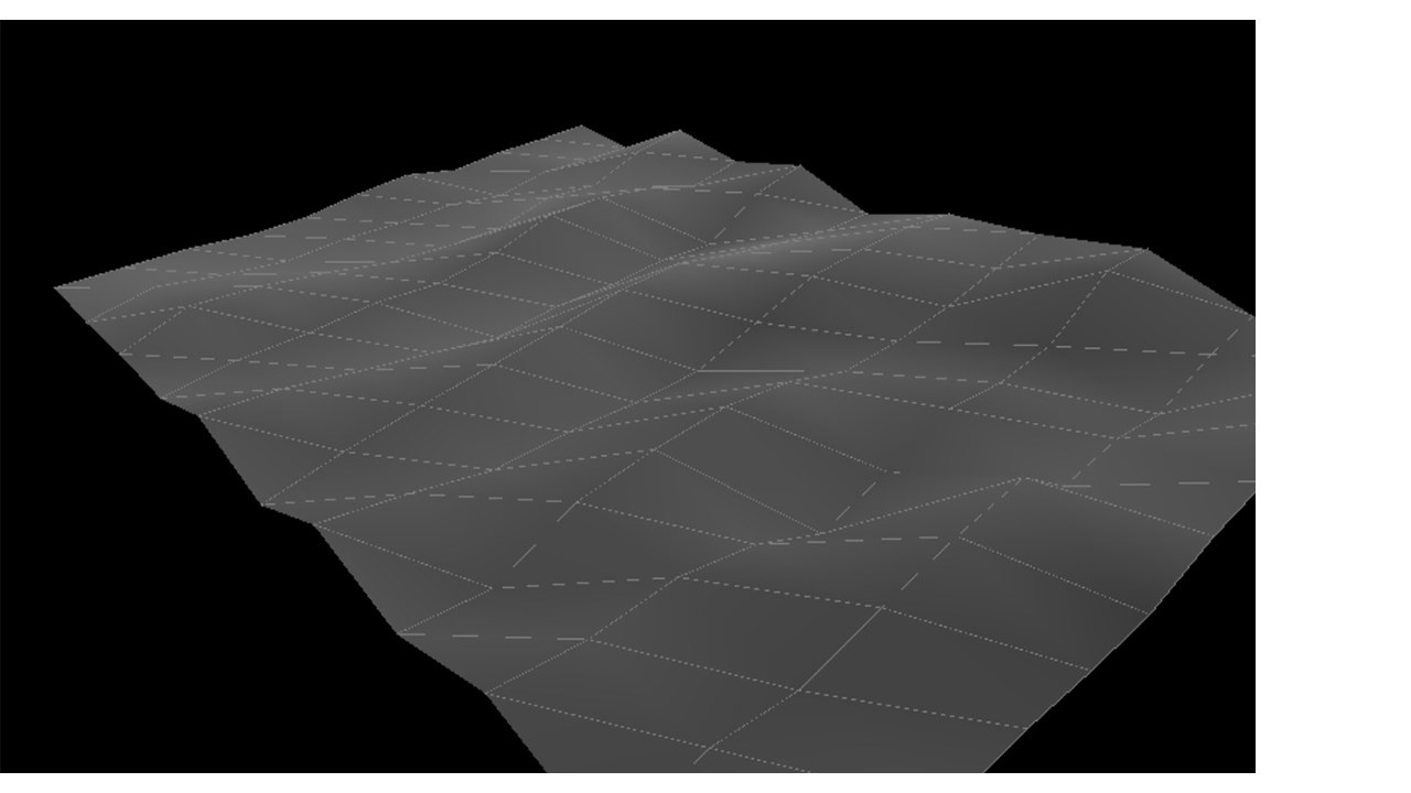
Digital Elevation Model API - Terrainizer (a solution to digital terrain model) is a cross browsers REST API supporting now a maximum of 2601 3D Points per request including all the selected rectangled surface as an array of equally distanced 3D Points as you may see in the figure below. The digital elevation model or digital terrain model (mesh 3D model) is based on a selecting rectangle of a slice on Earth (it may be also on oceans, seas). As data input you need to specify the North East Corner Latitude and Longitude and the South West Corner Latitude and Longitude (as upper right corner and the lower left corner of the selecting rectangle) and also the number of dividing segments on the width of the rectangle (npwidth) and the number of dividing segments on the height of the rectangle (npheight). The number of 3D Points is calculated as (npwidth+1)*(npheight+1). As more 3D points are, as smooth is the resulted mesh 3d model.
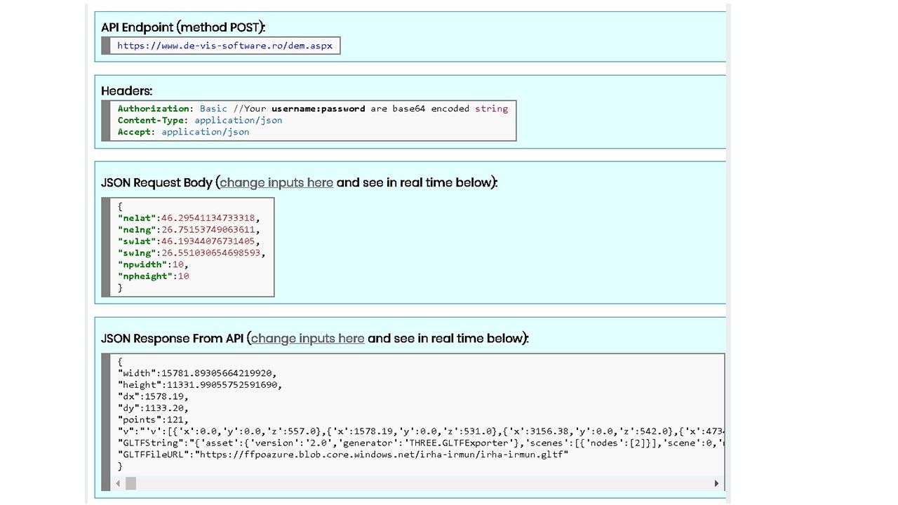
Allthough this digital terrain model API is intended for software development and therefore developers, we have also here an online application that may be used to get the GLTF file of the mesh 3D model alltogether with other useful data like 3D points coordinates (x, y, z), the width and the height of the selecting rectangle, dx (horizontal distance between 3D Points) and dy (vertical distance between 3D Points). Basically for digital elevation model API you send an authorized POST request in JSON format to the digital terrain model API endpoint and you get as JSON response a representing the parametrs given in the table below. You may use it for commercial purposes for paid packages.
Digital Elevation Model APP or API is useful for a large number of domains like: constructions, designers, architecture, 3D modelling, 3D simulation software, agriculture, oceanography etc.
For using our digital elevation model download API and/or APP (or mesh 3D model) you must create an account (free of charge, no card required), activate it from your received email, login and then start your TRIAL package with no fees as you can see at our pricing packages. After you have tested the digital terrain model API and/or APP and if you are satisfied, you may buy a paid package. You will always see at your Admin Console page the real resources consumption in real time, your invoices, you may see/edit/delete your profile or export log consents as GDPR instructed, you may read our FAQs.
Rask oversikt

Andre apper fra SC DE VIS SOFTWARE SRL

Route Optimization API, 100 addresses per RequestSC DE VIS SOFTWARE SRL SaaSRoute Optimization API, Maximum 100 addresses per Request
Applicable to:SaaS
NaN out of 5
CloudPronouncerSC DE VIS SOFTWARE SRLSaaSText To Speech API, 475 Voices M/F in 53 Languages
Applicable to:SaaS
NaN out of 5
Sun Position Detection APISC DE VIS SOFTWARE SRLSaaSDetects and localizez sun in a photo relative to the center of the photo using AI
Applicable to:SaaS
NaN out of 5
Dirty Solar Panel Detection APISC DE VIS SOFTWARE SRLSaaSDetects dirty solar panel from close-up photo using AI and powerful cloud infrastructure.
Applicable to:SaaS
NaN out of 5
Photo WedGifts Generator APPSC DE VIS SOFTWARE SRLSaaSBulk generates 10x15cm PhotoWedGifts from input photos and frames at 300DPI print resolution.
Applicable to:SaaS
NaN out of 5
Ved å hente dette produktet gir jeg Microsoft tillatelse til å bruke eller dele mine kontoopplysninger, slik at leverandøren kan kontakte meg angående dette produktet og relaterte produkter. Jeg godtar leverandørens vilkår for bruk og personvernerklæring og forstår at retten til å bruke dette produktet ikke kommer fra Microsoft, med mindre Microsoft er leverandør. Bruk av AppSource er underlagt separate vilkår og personvern.